Project Description
The objective of the project was to confirm the existence of adequate quantities of underground water in the Sarir well field, for the development of agriculture along the coastal area of the Sirt Gulf to cultivate about 65,000 acres.
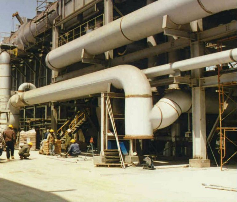
The main features of the project included drawing of underground water from aquifer Sarir well fi eld, collected by means of an 800 km long collection network and pumped for a distance of 350 km to the coast. Water was then transported for a further distance of 500 km along the coastal area of the bay, where it was stored and distributed.
Due to the very large size of the project and the relatively high cost of water lifting and transport, the studies and designs were developed to the highest possible standards where all phases were optimized, using dedicated mathematical models.
The project consisted of:
- Hydro-geological research and studies in Sarir well field covering an area of 30,000 km2 .
- Studies and research included:
- Well drilling to 900 m deep including uninterrupted long duration pumping tests to determine the aquifer discharge, water quality and drawdown.
- Computer studies using a mathematical model to determine the stepped drawdown for a life span of 100 years.
- Design of 230 production wells and layout to determine the average daily water discharge of 1,000,000 m3 .
- Design of 800 km water collecting network within the well field.
- Aerial and ground survey covering an area of 50,000 km2 including water production fields, pipeline routes and agricultural development zones.
- Agricultural soil surveys and classification of 375,000 acres on a reconnaissance level and 155,000 acres on a semi-detailed level, studies and research.
- Design of the pipelines and pumping facilities.
- Water reservoirs with a total storage capacity of 110,000,000 m3 .
- Design of irrigation and drainage methods and techniques.
- Determination of cropping patterns and crop rotation for each location.
- Animal breeding and related facilities.
- Agro-industrial development of the area using the agricultural and animal products.
- Soil conservation , erosion control and windbreaks.
- Determination of size of farm settlements, villages and public buildings necessary for the project.
- Design of the electrical system for the well field, 150 MW power station, 880km of overhead transmission lines (220 kV & 30 kV), 230 pole mounted transformers with associated switchgear and control equipment for submersible pumps and dispatch and control center.
- 800 km of electrical transmission and distribution lines (30 kV & 10 kV) in the coastal area to supply a load of 77 MVA utilized in irrigation, agroindustries and farms.
- Study of the infrastructure required for the project including potable water, sewage disposal, generation and transmission of electricity, public lighting and telephones.
- Design of 460 km of roads network to serve the development zone.
- Full optimization of all elements and parts of the project.
- Economic evaluation of the project including estimation of agricultural, animal and industrial production and marketing.
Activities
- Civil Works
- Electrical
- Roads
Scope
- Feasibility study
- Preliminary design
Client
General Water Authority, Libya
LOCATION
libya
,gulf-of-sirt-and-sarir-areas
,project sheet
share this project